


Camping Near Death Valley National Park
California, Nevada | Established 1994
About Death Valley National Park
Death Valley National Park protects 3.4 million acres of extreme desert landscape straddling the California-Nevada border, making it the largest national park outside Alaska. The park holds the record for the highest reliably recorded air temperature on Earth at 134 degrees (July 10, 1913) and contains Badwater Basin at 282 feet below sea level, the lowest point in North America. Just 15 miles away, Telescope Peak rises to 11,049 feet, creating over 11,000 feet of vertical relief.
Nine developed campgrounds offer about 600 sites ranging from the popular Furnace Creek (136 sites with 18 full-hookup spots at $44/night) to free primitive campgrounds at higher elevations. Sunset Campground (270 sites, $12/night) is the largest and operates only during the cooler months from October through April. Summer temperatures routinely exceed 120 degrees, making camping from June through September extremely dangerous without air conditioning.
The park's vast scale means attractions are spread across enormous distances. Badwater Basin, Zabriskie Point, Mesquite Flat Sand Dunes, Artists Drive, and Dantes View can fill several days of exploration. Fuel is available only at Furnace Creek, Stovepipe Wells, and Panamint Springs. Cell service is nonexistent through most of the park, and self-sufficiency is essential for safe travel in this remote landscape.
Camping Tips for Death Valley
- Camp between October and April only. Summer temperatures exceed 120 degrees and have reached 134 degrees. Summer camping without air-conditioned shelter is extremely dangerous and not recommended.
- Furnace Creek is the only campground with hookups, offering 18 full-hookup sites at $44 per night (30/50 amp electric, water, sewer). Reserve through Recreation.gov for the October through April peak season.
- Carry at least two gallons of water per person per day plus extra for your vehicle. Dehydration is the leading medical emergency in the park. Water is available only at developed areas, not along roads or trails.
- Fuel up at every opportunity. Gas is available only at Furnace Creek, Stovepipe Wells, and Panamint Springs, and distances between them exceed 50 miles. Running out of gas in Death Valley is a life-threatening situation.
- Cell service is essentially nonexistent throughout the park. Carry a paper map, tell someone your itinerary, and consider a satellite communication device. GPS navigation can be unreliable on backcountry roads.
RV Parks & Campgrounds Near Death Valley National Park

41.Texas Springs Campground
Texas Springs Campground is located within Death Valley National Park. The campground is open year-round and offers developed campsites with amenities such as flush toilets and...
Show more
42.Fossil Falls Campgrounds Recreation Site
Fossil Falls Campground is a recreation site located in California, managed by the Bureau of Land Management. The campground offers a unique opportunity to experience the natural...
Show more43.Furnace Creek Campground
Furnace Creek Campground is located in Death Valley National Park, California. It is a developed campground with 136 individual sites, including 18 with hookups. The campground is...
Show more
44.Mesquite Spring Campground
Mesquite Spring Campground is a campground located within Death Valley National Park. It offers a unique experience for visitors, with its desert landscape and opportunities for...
Show more45.Diaz Lake
Diaz Lake is a 10-acre lake located in the Eastern Sierra region of California. The lake is a popular spot for fishing, boating, and birdwatching. The lake is surrounded by a...
Show more
46.Sage Flat Campground
Sage Flat Campground is located in the Inyo National Forest. The campground offers various recreation opportunities, including hiking, fishing, and horse riding. The area is known...
Show more
47.Independence Creek Campground
Unfortunately, I was unable to find any information about the Independence Creek Campground. Please check the website for more information.
Show more48.Mahogany Flat Campground
Mahogany Flat Primitive Campground is located in Death Valley National Park. The campground is open year-round and offers 11 campsites for tents and small RVs. The campsites are...
Show more
49.Portuguese Joe Campground
Portuguese Joe Campground is a scenic camping destination located near Lone Pine, California, accessible via Whitney Portal Road off U.S. 395. This rustic campground offers 20...
Show more50.Grandview Campground
The Inyo National Forest offers a variety of recreation opportunities, including biking, climbing, fishing, hiking, horse riding, hunting, off-highway vehicle riding, outdoor...
Show moreShowing 41–50 of 101 campgrounds within 75 miles
Frequently Asked Questions
What campgrounds are inside Death Valley?
Death Valley has nine developed campgrounds. Furnace Creek (136 sites, $30/night standard, $44/night hookup) operates year-round with 18 full-hookup sites. Sunset (270 sites, $12/night) and Texas Spring (106 sites, $20/night) operate October through April. Stovepipe Wells has 14 full-hookup sites. Mesquite Spring and several others are first-come.
Furnace Creek is the most popular and best-equipped campground with flush toilets, water, a dump station, and the park's only electric hookup sites. Sunset is the largest and most affordable, ideal for RVs and self-contained camping. Texas Spring sits slightly above the valley floor with partial shade. Higher-elevation campgrounds like Wildrose, Emigrant, and Thorndike are free but primitive with no water. Mesquite Spring was damaged by flooding and may have limited availability.
How hot does Death Valley get?
Death Valley holds the record for the highest reliably recorded air temperature on Earth at 134 degrees (July 10, 1913). Summer temperatures regularly exceed 120 degrees, with July averaging a high of 116 degrees and a low of 88 degrees. Ground surface temperatures can exceed 200 degrees.
The extreme heat makes summer visits dangerous. Hikers have died from heat exposure even on short walks. Between June and September, limit outdoor activity to before 10 AM and after 5 PM, carry far more water than you think you need, and stay near your vehicle. Air-conditioned shelter is essential. The park service strongly discourages hiking in summer and prohibits hiking in low-elevation areas when temperatures exceed 115 degrees.
Can I bring my dog to Death Valley?
Dogs on a leash of six feet or shorter are allowed in campgrounds, on paved and dirt roads, and in developed areas. Dogs are prohibited on all trails including paved ones like Zabriskie Point. The only trail-like path open to dogs is the paved bicycle path to Harmony Borax Works (1 mile).
Death Valley's extreme heat makes conditions dangerous for dogs even more than for humans. Never leave a dog in a vehicle, as interior temperatures can exceed 170 degrees within minutes. Hot ground burns paw pads when surface temperatures exceed 150 degrees, which occurs from May through September. If bringing a dog, visit only during the cooler months and limit outdoor time during the warmest part of the day.
What are the must-see attractions in Death Valley?
Top attractions include Badwater Basin (lowest point in North America at -282 feet, vast salt flats), Zabriskie Point (colorful badlands, famous sunrise views), Mesquite Flat Sand Dunes (100-foot dunes near Stovepipe Wells), Artists Drive (one-way loop through colorful mineral deposits), and Dantes View (panoramic overlook 5,475 feet above Badwater).
The Racetrack Playa features mysterious sliding rocks that move across a flat dry lake bed, but reaching it requires 27 miles of rough dirt road and a high-clearance vehicle. Titus Canyon is a one-way dirt road through a narrow slot canyon ending at a ghost town. Telescope Peak Trail climbs 14 miles round trip to the park's highest point at 11,049 feet. Golden Canyon and Natural Bridge are short hikes accessible from the main road.
When is the best time to visit Death Valley?
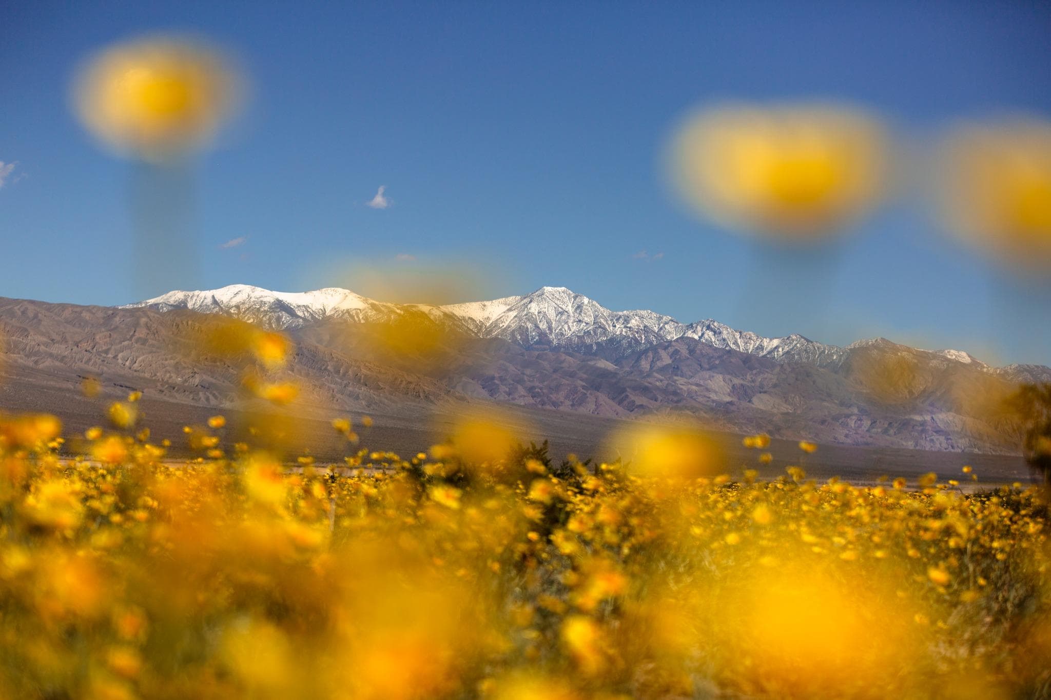
November through March offers the most comfortable weather with daytime highs in the 60s to 70s and cool nights. February through April brings the possibility of wildflower blooms in years with good winter rainfall. Avoid June through September when temperatures exceed 120 degrees daily.
The peak visitor season runs from October through April when campgrounds are open and temperatures are manageable. Spring wildflower blooms, known as superblooms in exceptional years, draw large crowds in March and April. Winter can bring rare frost at higher elevations and snow on the surrounding mountains, creating dramatic contrast with the desert floor. The least crowded time is mid-November through mid-December before the holiday season.
How big is Death Valley National Park?
Death Valley covers 3.4 million acres (5,270 square miles), making it the largest national park in the contiguous United States. The park stretches 140 miles north to south and up to 40 miles east to west. Driving between major attractions can take over two hours.
The park's size means visitors should focus on one region per day rather than trying to see everything. Furnace Creek is the central hub with the visitor center, campgrounds, a general store, and fuel. Stovepipe Wells and Panamint Springs are the only other locations with fuel and limited supplies. Scenic drives connect the major points of interest, but many backcountry roads require high-clearance or four-wheel-drive vehicles.
Is there cell service in Death Valley?
Cell service is essentially nonexistent throughout most of Death Valley. Limited connectivity may be available near Furnace Creek and Stovepipe Wells, but coverage is unreliable. GPS navigation units can be inaccurate on backcountry roads.
The lack of cell service combined with extreme remoteness and heat makes self-sufficiency critical. Always carry a detailed paper map of the park. Tell someone your specific itinerary and expected return time before entering the backcountry. A satellite communication device (such as a Garmin inReach or similar) provides a communication lifeline if you break down or need emergency assistance in areas without coverage.
Are there RV hookups at Death Valley campgrounds?
Furnace Creek Campground offers 18 full-hookup sites (30/50 amp electric, water, sewer) at $44 per night. Stovepipe Wells has 14 full-hookup RV sites operated by the lodge. Panamint Springs Resort on the park's west side also offers full hookups. All other campgrounds have no hookups.
Full-hookup sites at Furnace Creek are the most sought-after in the park and should be reserved well in advance through Recreation.gov for the October through April season. Sunset Campground (270 sites, $12/night) is the best option for self-contained RVs without hookups. No dump station is available at Sunset. Texas Spring has no dump station either. Furnace Creek has the only park-operated dump station.
Quick Facts
- Entrance Fee
- $30/vehicle (7 days)
- Best Time to Visit
- November – March
- Nearest Town
- Beatty, NV, Pahrump, NV, Lone Pine, CA
- Elevation
- -282 – 11,049 ft
- Park Size
- 3,400,000 acres
- Annual Visitors
- ~1.7 million