Camping Near Black Canyon of the Gunnison National Park
Colorado | Established 1999
About Black Canyon of the Gunnison National Park
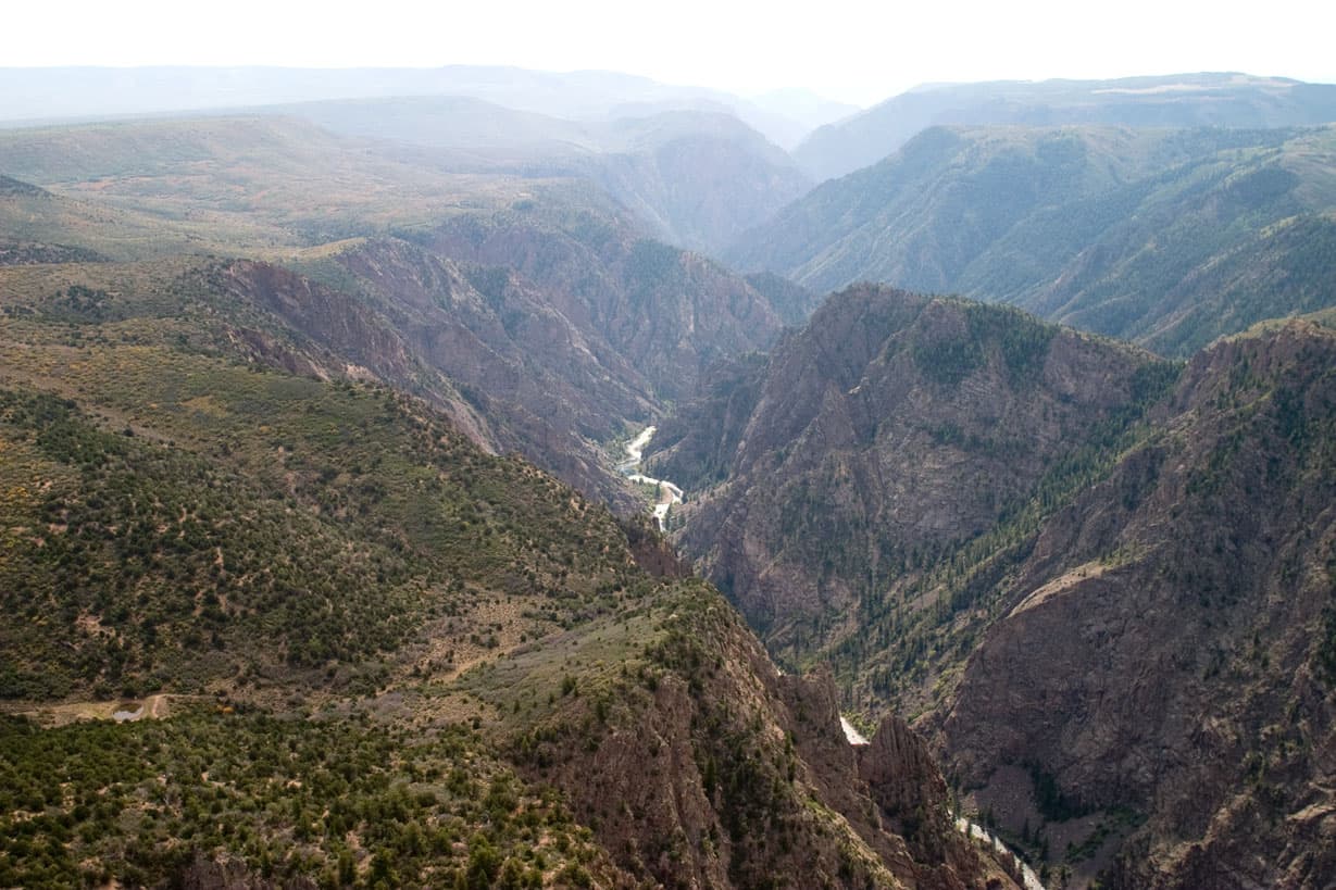
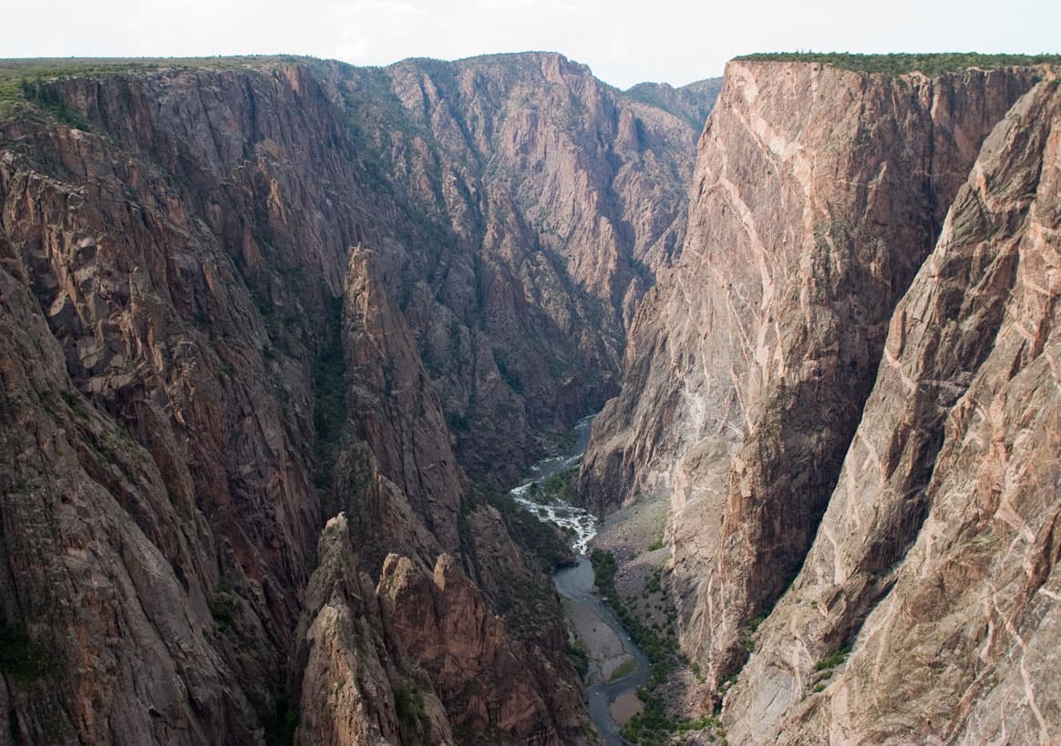
Black Canyon of the Gunnison National Park protects 30,385 acres where the Gunnison River carved a narrow gorge through 1.7-billion-year-old Precambrian metamorphic rock. At its narrowest point, the canyon spans just 1,100 feet rim to rim while dropping 2,000 feet to the river below. The dark walls receive as little as 33 minutes of direct sunlight per day at the deepest points, giving the canyon its name.
South Rim Campground offers 88 sites with some electric hookups at $22 to $34 per night, located 1.5 miles from the South Rim Visitor Center. North Rim Campground provides 13 first-come, first-served sites at $16 per night, accessed via 7 miles of unpaved road requiring high-clearance vehicles. East Portal Campground (15 sites, $20 per night) sits at the canyon floor along the Gunnison River via the steep East Portal Road. Montrose (19 miles) serves as the primary gateway with full services.
Camping Tips for Black Canyon of the Gunnison
- Reserve South Rim Campground six months in advance through recreation.gov. The 88 sites fill quickly for June through September. Some loops offer electric hookups at $34 per night; standard sites cost $22 per night. The campground sits at 8,200 feet with flush toilets and potable water seasonally.
- North Rim Campground requires no reservation and offers 13 first-come, first-served sites at $16 per night with vault toilets. Arrive before 10 a.m. for best availability. The access road is unpaved for 7 miles and requires high-clearance vehicles. No potable water is available after seasonal shutoff.
- Pack layers for dramatic temperature swings at 8,200 feet elevation. Summer days reach the mid-70s but nights drop into the 40s. Afternoon thunderstorms develop rapidly from July through August with dangerous lightning on the exposed rim. Finish all rim hikes by early afternoon during storm season.
- The South Rim and North Rim are separated by the canyon with no bridge between them. Driving between rims takes two to three hours via Montrose and Crawford. Commit to one rim per trip or plan a full day for logistics if visiting both sides.
- East Portal Campground at the canyon floor offers 15 sites at $20 per night along the Gunnison River for fishing access. The steep East Portal Road descends 2,000 feet in 5 miles with 16 percent grades. Vehicles over 22 feet are prohibited on this road.
RV Parks & Campgrounds Near Black Canyon of the Gunnison National Park

151.The Cozy Lake City RV
The Cozy Lake City RV is a welcoming campground located in Lake City, Colorado, offering a peaceful retreat in the heart of the Rocky Mountains. This RV-friendly facility provides...
Show more
152.Cebolla Campground
Cebolla Campground is located near Creede, Colorado, offering a peaceful camping experience in the heart of the San Juan Mountains. This campground provides a convenient base for...
Show more153.Mason Family Campground
Mason Family Campground is a welcoming campground located in Cathedral, Colorado, offering a great base for exploring the scenic beauty of the region. The campground caters to...
Show more154.Tumble Creek Trailhead (recgovnpsdata)
Tumble Creek Trailhead is a campground located in Lake City, Colorado, offering access to outdoor recreation in the San Juan Mountains region. The facility serves as a convenient...
Show more155.Ledges Cottonwood Area
Ledges Cottonwood Area is a campground located in Piñon, Colorado, offering a peaceful retreat in the scenic Colorado landscape. This campground provides a great base for...
Show more156.Black Canyon Dispersed
Black Canyon Dispersed is a campground located in Montrose, Colorado, offering a rustic camping experience in the scenic Black Canyon area. This dispersed camping option provides...
Show moreShowing 151–156 of 156 campgrounds within 50 miles
Frequently Asked Questions
What is the difference between South Rim and North Rim camping?
South Rim Campground (88 sites, $22 to $34 per night) has flush toilets, seasonal potable water, some electric hookups, and sits 1.5 miles from the visitor center via paved road. North Rim (13 sites, $16 per night) has vault toilets only, no running water, and requires 7 miles of unpaved road with high clearance.
South Rim suits families and RV campers with more amenities, paved access, and ranger programs at the nearby visitor center. North Rim offers solitude and a remote experience with far fewer visitors. North Rim Road may be impassable in wet weather. Both campgrounds have fire rings and picnic tables. South Rim accepts reservations through recreation.gov; North Rim is first-come, first-served only. Winter camping is possible at both rims but water systems shut off from mid-October through mid-May.
How dangerous are the afternoon thunderstorms?
Afternoon thunderstorms are common from July through August, developing rapidly by 2 to 3 p.m. with little warning. Lightning risk is high on the exposed canyon rim where there is no shelter. Plan all rim hikes to finish by 1:30 p.m. during summer storm season and retreat to your vehicle immediately.
Thunderstorms can appear from clear skies within 30 minutes. Wind gusts reach 40 mph or more during storms, creating hazardous conditions on narrow rim trails. Lightning strikes the exposed canyon rim regularly. Spring (April through May) and fall (September through October) have significantly fewer storms, making them safer for extended rim exploration. Check hourly weather forecasts before departing camp. If caught on the rim, crouch low away from the edge and avoid isolated trees.
Can I hike to the canyon floor?
Yes, but canyon routes are extremely strenuous, unmaintained, and require route-finding skills. The Gunnison Route drops 1,800 feet in one mile via chains, loose rock, and steep scrambling. A free wilderness permit from the visitor center is required. The park rates all inner canyon routes as Class III to Class IV scrambles.
Inner canyon descents are not trails but unmarked routes requiring agility, upper body strength, and comfort with severe exposure. The Gunnison Route is the most commonly attempted descent, reaching the river for fishing access. Other routes including SOB Draw and Slide Draw are more technical. Allow four to six hours roundtrip. Carry at least two liters of water and a filter for river water at the bottom. Rockfall from crumbling canyon walls is a constant hazard. Helmets are recommended.
Is fishing allowed in the Gunnison River?
Yes. The Gunnison River through the Black Canyon is designated Gold Medal trout water by Colorado Parks and Wildlife, with trophy-sized brown and rainbow trout. Access the river via East Portal Road or by descending inner canyon routes with a wilderness permit. A valid Colorado fishing license is required.
East Portal Campground provides the easiest river access without a strenuous canyon descent. The river section through the park uses artificial flies and lures only with specific size and bag limits. Gold Medal designation means the river produces trout 14 inches or longer at high rates. Wade fishing is standard since the river is too narrow and rocky for boats in most sections. Water levels fluctuate based on upstream dam releases from Crystal Reservoir.
What are the best rim viewpoints?
Painted Wall View displays Colorado's tallest cliff face at 2,250 feet. Chasm View offers a direct look into the narrowest section of the canyon at 1,100 feet across. Dragon Point, Tomichi Point, and Pulpit Rock each provide distinct perspectives along the 7-mile South Rim Road with short walks from parking areas.
South Rim Road has 12 designated overlooks accessible from the main road, each with short walks to the rim. North Rim offers fewer but equally dramatic viewpoints including the Narrows View and Green Mountain. Many overlooks have no railings and unfenced cliff edges, so exercise extreme caution. The Rim Rock Nature Trail (1 mile) connects several South Rim viewpoints through pinyon-juniper woodland. Evening light from June through August creates dramatic shadow play on the dark canyon walls.
Does cell service work at the campgrounds?
Cell service is limited and unreliable at South Rim Campground, depending on your carrier. North Rim Campground has virtually no cell coverage. The canyon walls and remote location block most signals. Download offline maps, trail information, and emergency contacts before arriving at the park.
South Rim occasionally picks up weak signals near the visitor center but coverage is inconsistent. Wi-Fi is not available at either campground or the visitor center. Satellite communicators such as Garmin inReach devices work throughout the park for emergency communication. Montrose (19 miles south) has full cell service for trip planning and supply runs. The isolation is part of the experience but requires advance preparation for navigation and communication.
When is the best time to visit for fewer crowds?
Late April through May and September through October offer mild weather, smaller crowds, and easier campsite availability. Wildflowers bloom in spring on the rim. Fall brings warm days in the 60s and 70s with cool nights and stable weather. Summer (June through August) draws the most visitors and fills campgrounds.
September camping provides warm daytime temperatures, clear skies, and significantly fewer visitors than summer peak. October can see frost overnight but clears to pleasant sunny days. Spring wildflowers including paintbrush and lupine bloom along the rim trails in May. Winter visitation is rare with cold temperatures ranging from 10 to 40 degrees and possible snow closures on North Rim Road. South Rim Road remains plowed in winter but campground water shuts off from mid-October through mid-May.
What supplies should I bring since the park has limited services?
Bring all food, water containers, and camping supplies since the park has no stores, restaurants, or gas stations. Montrose (19 miles) has grocery stores, hardware stores, fuel, and restaurants. The South Rim Visitor Center sells limited books and souvenirs but no food or camping supplies.
Stock up completely in Montrose before driving to the park. The nearest fuel is at the Highway 50 and Highway 347 junction (6 miles from the South Rim entrance). For North Rim visitors, Crawford (15 miles) has a small general store. Firewood may be available for purchase at the campground kiosk during summer but supply is not guaranteed. Bring your own firewood or a camp stove. The closest medical facility is Montrose Memorial Hospital, 25 miles from South Rim Campground.
Quick Facts
- Entrance Fee
- $30/vehicle (7 days)
- Best Time to Visit
- May – September
- Nearest Town
- Montrose, CO, Delta, CO, Paonia, CO
- Elevation
- 5,440 – 8,775 ft
- Park Size
- 30,385 acres
- Annual Visitors
- ~0.3 million